| Sources (hover for more info) |
| Civil Registration |
| Census |
| Poor Law Records |
Historic County Maps
Map scales are expressed in fractions such as 1:50,000, more commonly known as a 1-inch map or one where a little over one inch equals one mile. The lower the second number in the fraction or the higher the number in the common expression means that you have the best map for detailed research. The ideal maps for county research are the 6-inch (1:10,560) through the 25-inch (1:2500).
General County Maps
Late-19th Century Maps
The First edition of the Ordnance Survey maps was published between 1846-1899. It includes such details as nonconformist chapels. The 6-inch maps can be seen without charge at Old Maps. The 25-inch map of the area shown within the pink lines on the free map can be purchased by clicking on Buy A Map listed at the bottom of the screen.
T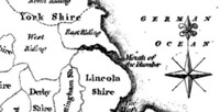 he Old Maps site has a useful gazetteer, but the British History site will allow you to examine the 25-inch maps for 18 English towns and cities for free. The British History website also has some free historic maps. Many of the 25-inch maps in the First and Second editions of the Ordnance Survey are being reprinted at a reduced scale of 14-inch maps by Alan Godfrey. To see those already at the FHL, put Godfrey's name in the Author box in the main menu of their catalog. Locate under his name the subject ‘Ordnance Survey’ and the county you are interested in. If the county is not listed under that subject, see if there is one available here from the publisher, but these maps cost money to order. For a smaller but growing selection of 25-inch maps on CD-ROM, visit Digital Archives, which also costs money to order.
Mid-19th Century Maps
The FHL has produced online county maps for 1851 showing all of the jurisdictions of interest to the genealogical researcher, entitled "England and Wales Jurisdictions 1851," which is located at FamilySearch Maps. For further details, see locations.
Early-19th Century Maps
The earliest maps generated by the Ordnance Survey are known as the Old Series 1-inch maps. They were published between 1805-1873. Facsimiles were released in two versions in the 1970s. Despite the small scale, the dates when they were drawn and their easy availability make this collection important. The first version reprinted by David & Charles in 1971 consists of 110 sheets of flat maps. The second version published in 1975 by H. Margary with an introduction by J.B. Harley is available in 8 large volumes.
BYU has both versions of the Old Series 1-inch maps. The flat maps are probably the easiest to use and are found in the BYU map cases under G 5750s 6336 .G7. The 8 bound volumes of the second version are in the BYU Map Collection under Quarto G 1810 .04. See the next paragraph on using the second version.
The FHL has two sets of the 8 volumes for the second version. (FHL Q 942 E3os) The spines of the volumes provide some idea of the county coverage of each volume. The names of the counties appear on the title pages. Go to Figure 2, "Sheet Breakdown" in each volume for a general guide to the pages on which the desired location is to be found.
Mid/Late-18th Century Maps
The Royal English Atlas, reprinted by David & Charles in 1971, contains maps produced in 1749-1763, with later alterations made mainly in 1777-1778. This atlas is in the BYU Map Collection under Folio G 1808 .B63 1765a.
17th Century Maps
The principal mapmakers for the counties of England were J. Blaeu, John Norden, Christopher Saxton, and John Speed. Individual maps for various counties can be found in the catalogs of both libraries under their names. As far as general collections, BYU has facsimiles of a collection by J. Blaeu in their map case under G 5750s 1648 .B5, #1-21, and by John Speed in the same case under G 5750s 1676 .S6, #1-17. The FLH has a modern version of John Speed's atlas at a slightly reduced scale under FHL Q 942 E7sj. A reprint of his 1614 edition is filed under FHL 942 E3spe X Large Folio.
Specific County Maps
This section is a brief description of some of the useful maps available in both libraries for various counties mainly before 1800. To be more thorough, check the catalogs of the respective libraries under the name of the county and the subject of maps, watching especially for the surnames of some of the best compilers of maps in the 17th and 18th centuries, such as Andrews & Dury, Blaeu, Burdett, Chapman & Andre, Day & Masters, Donn, Faden, Gascoyne, Jefferys, Morden, Norden, Oliver, Prior, Rocque, Saxton, Speed, Taylor, Warburton, and Yates. Printed collections listed below often have maps from several of these compilers.
Bedford
See M.F. Hopkinson's Old County Maps of Bedfordshire (FHL 942.565 E7L and BYU Map Collection GA 190 .L87 1976) for maps from the 17th through the 19th centuries, including Saxton's 1607, Speed's 1666, Morden�s 1680 & 1695, and Taylor's 1716.
Berkshire
See V.G. Scott's Berkshire (FHL 942.29 H2sc and BYU Map Collection Quarto DA670 .B4 S36x 1984) for large maps by Kip after Saxton's 1607, Morden's 1695, and Fullarton's 1843.A New Map of Berkshire with all the Hundreds (FHL 942.29 E7n) is a reprint of Speed's 1666. John Rocque's A Topographical Map of the County of Berkshire for 1752-1761 is particularly valuable. (FHL 942.29 E3r X Large Folio is a reprint. See the BYU catalog for an electronic map.)
Buckingham
See V.G. Scott's Buckinghamshire (BYU Map Collection Quarto DA 670 .B9 S36 1984) for a treatment similar to Berkshire listed in the previous entry.
Cheshire
A facsimile of Burdett's county map for 1777 in 4 sheets is in the BYU Map Case under G 5753 .C5 1777 .B87x. A Map of the Diocese of Chester divided into Deaneries &c is a photocopy from the Cheshire Record Office of the original map that was made about 1750. (FHL 942.71 E7t) The tithe maps, 1839-1849, for the townships along the border between Manchester and Stockport will be found under FHL Q 942.7 E7mi.
Cornwall
R. Kain's Historical Atlas of South-West England (FHL 942.3 E7h and BYU Map Collection Quarto G 1817 .W47 S1 H5 1999) includes peculiar jurisdictions on pages 214-215 and nonconformist maps on pages 222-225 for Devon and Cornwall.
Derbyshire
The 25-inch map of the county from the 2nd edition of the Ordnance Survey Maps, 1896-1900, is on FHL CD-ROM 2832.
Devon
See the above entry for Cornwall. Kain�s atlas has a town map of Plymouth for about 1625 on page 518. A facsimile of Donn�s map of Devon produced in 1765, including town maps of Exeter and Plymouth is available at BYU (Map Collection Quarto G 1818 .D4 D66x).
Essex
A facsimile of Chapman & Andre�s map of Essex produced in 1777 is available at BYU. It shows landowners and includes a town map of Colchester. (BYU Map Collection Folio G 1818 .E7 C5 1949) (A smaller reproduction will be found in FHL 942.67 B4e no. 11)
Gloucester
A Gloucestershire and Bristol Atlas published in 1961 includes Taylor's map produced in 1777. (FHL Q 942.41 E3g and BYU Map Collection Quarto G 1818 .G6 B7 1961) The Tithe Maps, 1831-1846, are available on microfilm at the FHL for the parishes in the Consistory of Bristol and the parish of Frampton Cottrell as follows:
- Parishes A-Be on film 2093195, items 1-7
- Parishes Bi-W on film 2092985, items 1-36
- Frampton Cottrell on film 2093081, item 11
Hampshire
Two Hundred and Fifty years of Map-making in the county of Hampshire (BYU Map Collection Folio G 1818 .H3 T85x 1976) includes maps by Saxton, Speed, Norden, Morden and Taylor. Taylor's map for 1759 adds the names of landowners.
Hertford
See V.G. Scott's Hertfordshire (FHL 942.58 H2sc and BYU Map Collection Quarto DA 670 .H5 S36x 1989) for large maps of Saxton's 1577, Blaeu's 1645, Kitchen's 1748, and Moule's 1842.
Kent
Atlas to History of Kent (FHL 942.23 E3atl) is meant to accompany the 2nd edition of Hasted's county history. Andrews & Dury's Topographical Map of the County of Kent produced in 1769 was reprinted in 1968 on 25 sheets in a 2-inch scale. (FHL 942.23 E3a X Large Folio) It includes the names of the gentry and even some farm and house names. A town map for Sandwich is on sheet 22. See sheet 25 for a key to the maps.
Lancashire
The 25-inch map of the county from the First edition of the Ordnance Survey Maps, 1888-1893, is on FHL CD-ROM no. 2870, parts 1-3. Yates' county map for 1786 was published in book form in 1968. (FHL 942.72 E7y) Yates� map is also available on a CD-ROM from Digital Archives. Also see the note in the above entry for Cheshire about tithe maps for townships along the Manchester-Stockport border.
Lincoln
Bennett's An Historical Atlas of Lincolnshire (FLH 942.53 E7ha and BYU Map Collection G 1818 .L56 H57x 1994) includes the wapentakes on map19, the archdeaconries and deaneries on map 25, workhouses on map 35, and nonconformist chapels on map 37.
Middlesex
Middlesex in the 18th Century is actually a reprint of Warburton's 1749 map. (FHL Map Case 942.1/L1 E7gr, no. 105) There are also reprints made in 1971 of Rocque's A Topographical Map of the County of Middlesex for 1754 in 2 sheets for the east and west. (FHL Map Case 942 E7r and BYU Map Case G 5753 .M5 1754 .R63x, plus a reprint from 1977 for the northeast under G 5753 .M5 .R6)
Norfolk
Faden's Map of Norfolk is a reprint of Donald & Milne's map of 1797. It is only a 1-inch scale but includes town maps of King's Lynn at 10-inch, Great Yarmouth at 15-inch, and Swaffham at 13-inch. (FHL 942.61 E7f and BYU Map Collection G 1818 .N67 F33x 1989)
Somerset
A facsimile of Day & Masters' map for 1782 was published in 1981. (FHL Map Case 942.38 B4s V.76, parts 1-9) See the above entry for Gloucester for tithe maps of the 4 parishes in this county that belonged to the Diocese of Bristol: Abbots Leigh, Bedminster, Brislington, and Whitchurch. The rest of Bedminster is on FHL film 2093083, item 4.
Suffolk
An Historical Atlas of Suffolk contains Hodskinson's map of 1783. (FHL 942.64 E7d and BYU Map Collection DA 670 .S9 H57x 1989)
Surrey
Two Hundred and Fifty years of Map-making in the County of Surrey includes maps from the 17th century and is especially helpful for Rocque's map of 1768. (BYU Map Collection Folio G 1818 .S97 T96 1974)
Sussex
Two Hundred and Fifty years of Map-making in the County of Sussex includes maps from the 17th century and is especially helpful for Yeakell & Gardner's map of 1778-9. There are also town maps for Brighton in 1779, Chichester in 1769, and Lewes in 1799. (FHL 942.25 E3m X Large Folio and BYU Map Collection Folio G 1818 .S9 T85 1970) See also V.G. Scott's Sussex(FHL 942.25 H2sc and BYU Map Collection DA 670 .S98 S36x 1985)
Wiltshire
Printed Maps of Wiltshire, 1787-1844 published in 1998 includes Tunnicliffe's map for 1791. (FHL 942.31 B4w, volume 52) See the above entry for Gloucester for tithe maps of the parishes of Ashley and Shorncote near Bristol.
York
Jeffery's map of the county was engraved in 1771. (FHL 942.74 E3j X Large Folio) It includes names of the gentry; nonconformist chapels; and town plans for Hull, Leeds, Ripon, Scarborough, Sheffield, and York. The key is on Plate V. Jeffery's map is also printed in Two Hundred and Fifty years of Map-making in the County of York (BYU Map Collection Folio G 1818 .Y6 J4 1973) and is available on CD-ROM from Digital Archives. Yorkshire, England, Ancient Parishes and Chapelries (FHL Map Case 942.74 E7ma and BYU Map Case G 5753 .Y6E4 1973 .H3) consists of two maps: Lawton's for 1842 and Teesdale's for 1817-1828. They are an excellent source for boundaries of archdeanconries, deaneries, and parishes.
Robert Morden's map of the East Riding was first published in 1695 and gives the hundreds and manors. (FHL Map Case 942.74 E7m) See also Susan Neave's An Historical Atlas of East Yorkshire (BYU Map Collection G 1818 .Y6:3 E3 S1 H5 1996)
Note: For other maps at the FHL pertinent to your research, search their listing of "British City and Town Maps" at Family Search. A transcript of the same material will be found in two 3-ring binders near the British Reference Desk (942 E 73c 1998, parts 1-2). For other maps at BYU try their "Index of Atlases & Gazetteers" located in the Map Dictionary Stand. It is available also on one of the computers near the reference counter. To find early maps on the web start with GenMaps and Map History and check the BYU catalog under Find Other Materials>Maps>Maps Online.